DORIS stations (SITE LOGS)
Click on any red dot on the map or name in the table to see a picture of the antenna and/or the site log.
Explore the DORIS network with Google Earth.
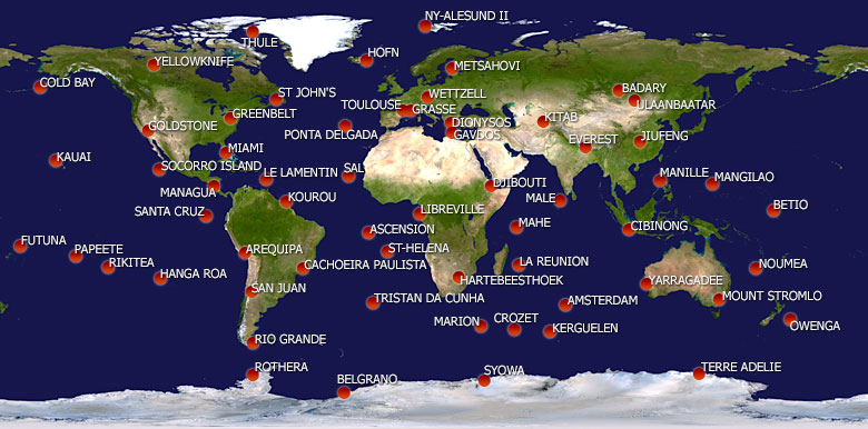
Map of the current DORIS network.
| The DORIS stations list | |||||
|---|---|---|---|---|---|
| Name | Country | Latitude | Longitude | Previous codes | Code |
| AJACCIO* | FRANCE | 41° 56' | 8° 46' | AJAB | |
| AMSTERDAM | FRANCE (Amsterdam Island) | -37° 48' | 77° 34' | AMSA, AMSB, AMTB, AMUB | AMVB |
| AREQUIPA | PERU | -16° 28' | 288° 30' | AREA, AREB | ARFB |
| ARLIT* | NIGER | 18° 47' | 7° 22' | ARLA | ARMA |
| ASCENSION | UNITED KINGDOM (South Atlantic Ocean) | -7° 55' | 345° 40' | ASDB | ASEB |
| BADARY | RUSSIA | 51° 46' | 102° 14' | BADA | BADB |
| BELGRANO | ANTARCTICA (Argentine base) | -77° 52' | 325° 22' | BELB | BEMB |
| BETIO | KIRIBATI | 1° 21' | 172° 55' | BETB | |
| BREST* | FRANCE | 48° 24' | 355° 30' | BRBA | |
| CACHOEIRA-PAULISTA | BRAZIL | -22° 41' | 314° 60' | CACB | CADB |
| CANBERRA-ORRORAL* | AUSTRALIA | -35° 38' | 148° 56' | ORRA | ORRB |
| CARIQUIMA* | CHILE | -19° 29' | 291° 19' | CARB | |
| CHATHAM-ISLAND* | NEW ZEALAND | -43° 57' | 183° 26' | CHAB | |
| CIBINONG | INDONESIA | -6° 29' | 106° 51' | CIBB, CICB | CIDB |
| COLD-BAY | U.S.A. | 55° 11' | 197° 18' | COBB | |
| COLOMBO* | SRI LANKA | 6° 54' | 79° 52' | COLA | |
| CROZET | FRANCE (Crozet Island) | -46° 26' | 51° 51' | CROB, CRPB, CRQB, CRQC | CRRC |
| DAKAR* | SENEGAL | 14° 44' | 342° 34' | DAKA | |
| DIONYSOS | GREECE | 38° 5' | 23° 56' | DIOA | DIOB |
| DJIBOUTI | DJIBOUTI | 11° 32' | 42° 51' | DJIA | DJIB |
| EASTER-ISLAND* | CHILE | -27° 9' | 250° 37' | EASA | EASB |
| EVEREST | NEPAL | 27° 57' | 86° 49' | EVEB | EVEC |
| FAIRBANKS* | U.S.A. | 64° 58' | 212° 29' | FAIA | FAIB |
| FLORES* | PORTUGAL (Azores) | 39° 27' | 328° 52' | FLOA | |
| FUTUNA | FRANCE (Wallis and Futuna) | -14° 18' | 181° 53' | FUTB, FUUB | FUUC |
| GALAPAGOS* | ECUADOR | 0° 54' | 270° 23' | GALA | |
| GAVDOS | GREECE | 34° 50' | 24° 7' | GAVB | GAVC |
| GOAT* | U.S.A. | 19° 19' | 204° 50' | GOAB | |
| GOLDSTONE | U.S.A. | 35° 15' | 243° 12' | GOLA, GOMA, GOMB | GONC |
| GRASSE | FRANCE | 43° 45' | 6° 55' | GR3B | GR4B |
| GREENBELT | U.S.A. | 39° 1' | 283° 10' | GREB | GRFB |
| GUAM* | U.S.A. (Mariana Islands) | 13° 32' | 144° 55' | GUAB | |
| HANGA ROA | CHILE | -27° 10' | -109° 26' | HROC | |
| HARTEBEESTHOEK | SOUTH AFRICA | -25° 53' | 27° 42' | HBKA, HBLA, HBKB, HBLB | HBMB |
| HAWAIIAN VOLCANO* | U.S.A. | 19° 25' | 204° 43' | HVOA | |
| HOFN | ICELAND | 64° 16' | -15° 12' | HOFC | HOGC |
| HUAHINE* | FRANCE (French Polynesia) | -16° 44' | 208° 58' | HUAA | |
| IQUIQUE* | CHILE | -20° 13' | 290° 6' | IQUB | |
| JIUFENG | CHINA | 30° 31' | 114° 29' | JIUB, JIVB | JIWC |
| KAENA POINT* | U.S.A. | 19° 17' | 204° 53' | KAEB | |
| KAUAI | U.S.A. | 22° 7' | 200° 20' | KOKA | KOLB |
| KERGUELEN | FRANCE (Kerguelen Island) | -49° 21' | 70° 15' | KERA, KERB, KESB, KETB, KEUC, KEVC, KEWC, KEXC | KEYC |
| KITAB | UZBEKISTAN | 39° 8' | 66° 53' | KITA, KITB, KIUB | KIVC |
| KOUROU | FRANCE (French Guiana) | 5° 6' | 307° 22' | KRUA, KRVB, KRUB | KRWB |
| KRASNOYARSK* | RUSSIA | 55° 60' | 92° 48' | KRAB | KRBB |
| LA-REUNION | FRANCE (Mascarene Islands) | -21° 13' | 55° 34' | REUA, REUB, REUC | REVC |
| LE-LAMENTIN | FRANCE (Caribbean Islands) | 14° 36' | 299° 0' | LAOB | |
| LIBREVILLE | GABON | 0° 21' | 9° 40' | LIBA, LIBB | LICB |
| LIFOU* | FRANCE (New Caledonia) | -20° 47' | 167° 14' | LIFB | |
| MAHE | SEYCHELLES | -4° 41' | 55° 32' | MAHB | MAIB |
| MALE | MALDIVES | 4° 12' | 73° 32' | MALB, MALC | MAMC |
| MANAGUA | NICARAGUA | 12° 9' | 273° 45' | MNAC | |
| MANGILAO | U.S.A. (Mariana Islands) | 13° 26' | 144° 48' | MLAC | |
| MANILLE | PHILIPPINES | 14° 32' | 121° 2' | MANA | MANB |
| MARION-ISLAND | SOUTH AFRICA | -46° 53' | 37° 51' | MARA, MARB, MATB, MAUB | MAVC |
| METSAHOVI | FINLAND | 60° 15' | 24° 23' | META, METB | MEUB |
| MIAMI | U.S.A. | 25° 44' | 279° 50' | MIAB | |
| MONUMENT-PEAK* | U.S.A. | 32° 54' | 243° 35' | MONB | MOOB |
| MOUNT-STROMLO | AUSTRALIA | -35° 19' | 149° 1' | MSOB | MSPB |
| NOUMEA | FRANCE (New Caledonia) | -22° 14' | 166° 29' | NOUA, NOUB, NOWB, NOXB | NOXC |
| NY-ALESUND* | NORWAY | 78° 55' | 11° 56' | SPIA, SPIB | SPJB |
| NY-ALESUND II | NORWAY | 78° 56' | 11° 50' | SVAC | SVBC |
| OTTAWA* | CANADA | 45° 24' | 284° 18' | OTTA | OTTB |
| OWENGA | NEW ZEALAND | -44° 2' | 183° 38' | OWEC, OWFC | OWGC |
| PAPEETE | FRANCE (Polynesia) | -17° 35' | 210° 24' | PAPB, PAQB, PATB | PAUB |
| PARAMUSHIR* | RUSSIA | 50° 40' | 156° 7' | PASB | |
| PONTA-DELGADA | PORTUGAL (Azores) | 37° 45' | -25° 40' | PDLB, PDMB, PDNC | PDOC |
| PORT-MORESBY* | PAPUA NEW GUINEA | -9° 26' | 147° 11' | MORA, MORB | MOSB |
| PURPLE-MOUNTAIN* | CHINA | 32° 4' | 118° 49' | PURA | |
| QUINCY* | U.S.A. | 39° 59' | 239° 3' | QUIB | |
| RAPA* | FRANCE (Polynesia) | -27° 37' | 215° 40' | RAQB | |
| REYKJAVIK* | ICELAND | 64° 9' | 338° 5' | REYA, REYB | REZB |
| RICHMOND* | U.S.A. | 25° 37' | 279° 37' | RICA | RIDA |
| RIKITEA | FRANCE (Polynesia) | -23° 8' | 225° 2' | RIKB, RILB, RIMB | RIMC |
| RIO-GRANDE | ARGENTINA | -53° 47' | 292° 15' | RIOA, RIOB, RIPB, RIQB, RIRB | RISC |
| ROTHERA | ANTARCTICA (U. K. base) | -67° 34' | 291° 52' | ROTA, ROTB, ROUB, ROVB, ROWC, ROXC, ROZC | ROBC |
| SAINT ETIENNE DE TINEE* | FRANCE | 44° 15' | 6° 56' | STEA | |
| SAL | CAPE VERDE | 16° 44' | 337° 4' | SALB, SAPC, SAQC | SARC |
| SAN FELIX ISLAND* | CHILE | -26° 17' | 279° 54' | SAFB | |
| SAN JUAN | ARGENTINA | -31° 31' | -68° 37' | SJUC | SJVC |
| SANAA* | YEMEN | 15° 21' | 44° 11' | YENB | |
| SANTA-CRUZ | ECUADOR | 0° 45' | 269° 42' | SCRB, SCRC | SCSC |
| SANTA-MARIA* | PORTUGAL (Azores) | 36° 59' | 334° 50' | SAMB | |
| SANTIAGO* | CHILE | -33° 9' | 289° 20' | SANA, SAOB | SANB |
| SIGNY ISLAND* | ANTARCTICA (U. K. base) | -60° 43' | 314° 24' | SIGA | |
| SOCORRO | MEXICO | 18° 44' | 249° 3' | SOCA, SODA, SODB, SOEB | SOFC |
| ST-HELENA | UNITED KINGDOM (South Atlantic Ocean) | -15° 57' | 354° 20' | HELA, HELB | HEMB |
| ST-JOHN-S | CANADA | 47° 36' | 307° 19' | STJB, STKB, STKD | STKC |
| SYOWA | ANTARCTICA (Japanese base) | -69° 0' | 39° 35' | SYOB, SYPB | SYQB |
| TANNA* | VANUATU | -19° 32' | 169° 17' | TANB | |
| TERRE-ADELIE | ANTARCTICA (French base) | -66° 40' | 140° 0' | ADEA, ADEB, ADFB, ADGB | ADHC |
| THULE | DENMARK (Greenland) | 76° 32' | 291° 11' | THUB | |
| TOULOUSE | FRANCE | 43° 33' | 1° 29' | TLSA, TLIA, TLHA | TLSB |
| TRISTAN-DA-CUNHA | UNITED KINGDOM (South Atlantic Ocean) | -37° 4' | 347° 41' | TRIA, TRIB | TRJB |
| TROMSO* | NORWAY | 69° 40' | 18° 56' | TROA | |
| ULAANBAATAR | MONGOLIA | 47° 52' | 107° 3' | ULAC | |
| WAIMEA* | U.S.A. | 20° 1' | 204° 20' | WAIA | |
| WALLIS* | FRANCE (Wallis and Futuna) | -13° 16' | 183° 49' | WALA | |
| WETTZELL | GERMANY | 49° 9' | 12° 53' | WEUC | |
| YARRAGADEE | AUSTRALIA | -29° 3' | 115° 21' | YARA, YARB | YASB |
| YELLOWKNIFE | CANADA | 62° 29' | 245° 31' | YELA, YELB | YEMB |
| YUZHNO-SAKHALINSK* | RUSSIA | 47° 2' | 142° 43' | SAKA | SAKB |
DATA NOT AVAILABLE
In the above table, where the DORIS stations are sorted by name, the four characters code is an unique identifier of the antenna position and type, used for the identification of the data files. When an antenna is moved, a new code is assigned to the new position of the reference point.
( * ) Removed sites.
 $linkStart = '<a href="/component/content/?id=46&Itemid=71&code='%20;<br%20/><img%20src="plugins/editors-xtd/sourcerer/images/tab.png" alt=" " border="0" />if ($serveurCourant == "ign") {$autreServeur = "cddis";}else {$autreServeur = "TLSB";}echo $linkStart . $autreServeur . "\">TEST</a>";