The pages of the Combination Center provide information about the activity and products of the Combination Center of the International DORIS Service (IDS). They are mainly of interest to the IDS Analysis Centers as well as to other other users, including mission flight times with responsibilities for precise orbit determination.
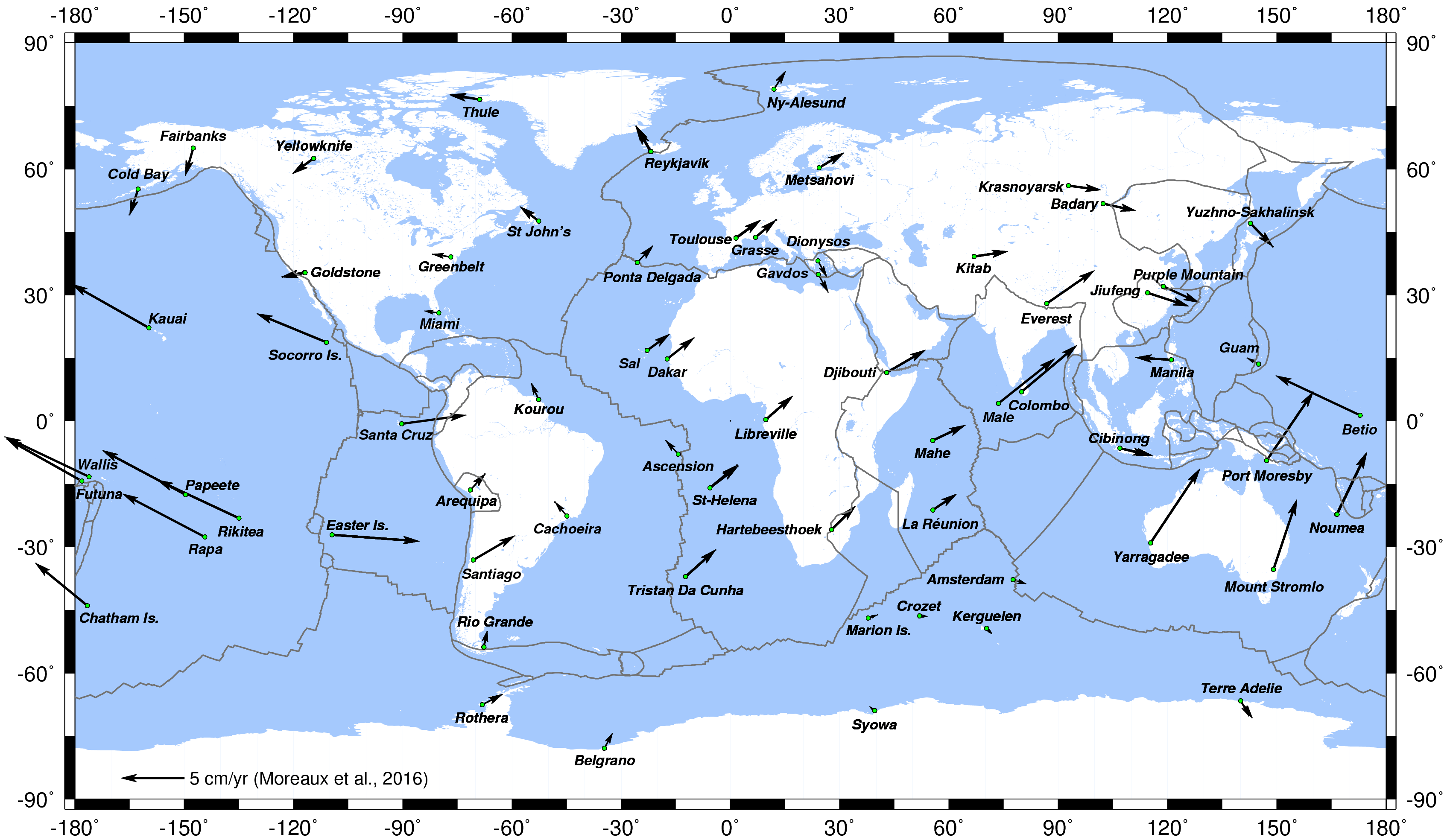
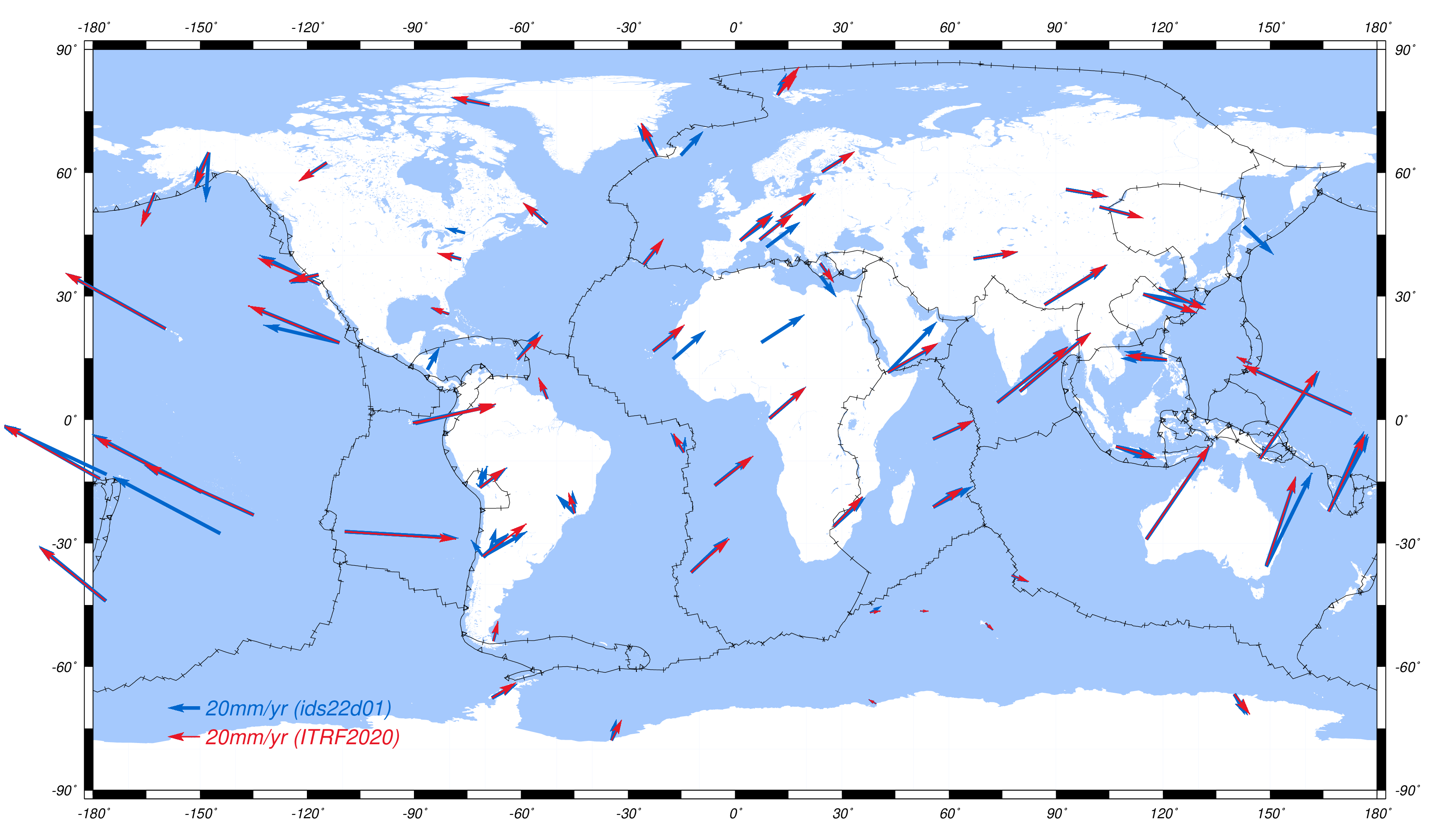
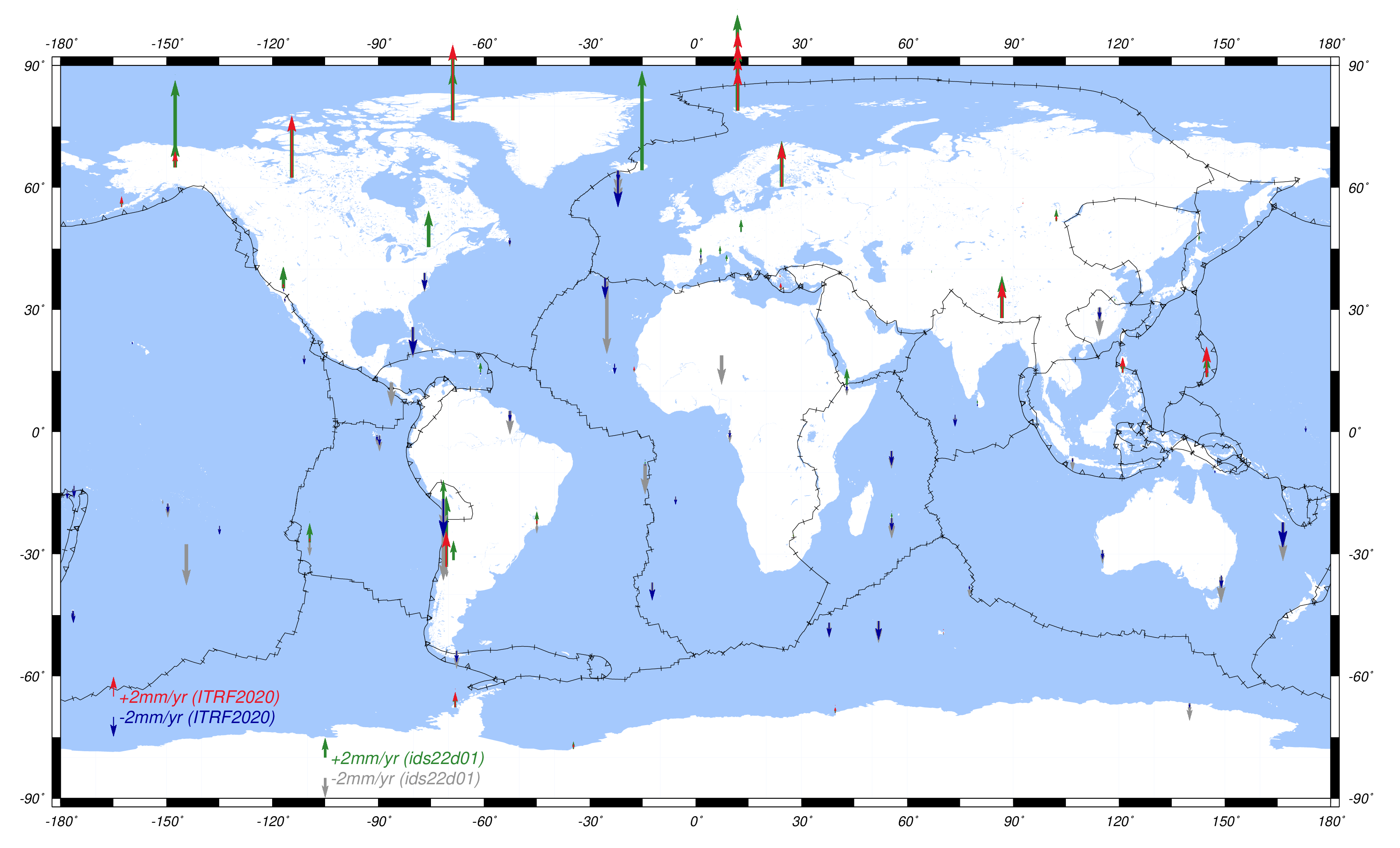
Horizontal displacement of the DORIS stations, reflecting the plate tectonique motion (Credits CNES/CLS/IDS)
Reference: Moreaux et al. (2016)
Activity of the Combination Center
Currently, six IDS Analysis Centers (ESA, GOP, GRG, GSC, IGN and INA) provide direct input for the official IDS products (station coordinates and Earth Orientation Parameters - EOPs). In addition, after the success of the pilot project to deliver an IDS combined solution for the ITRF2008 realization, the IDS decided to extend the combination process to an operational service. Thus, since 2010, the IDS Combination Center (CC) routinely evaluates the IDS AC station position and EOPs series and combines it to form the official IDS combined solution. The IDS CC is also in charge of the generation of all the DORIS coordinate time series from all the IDS AC (in addition to the IDS CC) SINEX series.
Since the realization of the ITRF2014, the IDS CC is responsible for the elaboration and update of the DPOD solution, i.e. DORIS station positions and velocities for the Precise Orbit Determination (POD) of the DORIS satellites.
All the computations realized by the IDS Combination Center are based on the IGN CATREF (Combination and Analysis of Terrestrial Reference Frames) package (Altamimi et al., 2002).
The Products
Weekly solutions
Every three months (with a latency of three months), the six IDS ACs submit SINEX solutions including weekly station positions, daily EOPs and the full covariance matrix. After evaluation by the IDS Combination Center, these solutions are combined in a standard least-squares adjustment to form the IDS weekly combined solutions.
The evaluation of the IDS AC solution consists of monitoring the similarity transformation parameters (the Helmert parameters) of the series with respect to the current ITRF realization as well as of analyzing the EOP differences with the IERS C04 series. The Helmert parameters, global station position 3D weighted residuals and EOP differences can be visualized through the IDS web service.
Station Coordinate Time series
After alignment of the weekly SINEX files on the current ITRF, for all the ACs and all the DORIS stations, the IDS CC generates the coordinate time series. These time series are stored in the STCD files to be downloaded from the IDS Data Centers. Note that these coordinate time series can also be visualized from the IDS web service (see for exemple the time series for Toulouse).
Besides the weekly combined solutions, a long-term DORIS position and velocity cumulative solution is updated and released every three months. In that solution, a piecewise linear (position+velocity) model is used to describe the station motions. The cumulative position and velocity solution is obtained from the stacking of the weekly solution files and is then aligned to the current ITRF. The residuals of this stacking are of particular interest since they depict non-linear station motions.
From the DORIS cumulative solution, the IDS CC generates the DPOD solution. This solution contains positions and velocities of all the DORIS tracking stations for Precise Orbit Determination (POD) applications. It differs from the cumulative solutions by (1) it also includes position and velocity of the newest DORIS stations which were not already observed by the IDS ACs and, (2) between two successive DPOD solutions, for all the stations, we only update the positions if the new ones significantly differ from the previous ones.
DORIS Sinex master file
To facilitate the access to the geographic positions of all the DORIS stations, the IDS has created a new IDS product: the DORIS SINEX Master file.
In addition to the geographic positions, that file also contains for each DORIS station information (type and eccentricity) of the antennas in SINEX format. That file, maintained by the IDS Combination Center, is available from the IDS Central Bureau ftp site
Product names
Network products
-
dpod2014_vx.y.snx.Z: DPOD solution (“x.y” denotes the version number).
-
dpod2014_vx.y.txt.Z: DPOD solution without covariance matrix.
-
idsyydxx.snx.Z: cumulative solution (“yy” denotes the year of submission and “xx” stands for the series number).
-
idsyydddwdxx.snx.Z: weekly combined solution (“yy” stands for the last two digits of year of the first observation, “ddd” for three-digit day of year of the first observation, and “xx” for the series number).
One-station products
-
idsyywdxx.stcd.aaaa.Z: time series of station coordinates (“yy” denotes the year of submission, “xx” stands for the series number, and “aaaa” denotes the four-character station acronym).
-
idsyywdxx.stcd.aaaa.gif: plot of time series of station coordinates.
Archive
These official products are available at the IDS Data Centers, CDDIS and IGN (alternate link)
 since ITRF2014")