Call for proposals for an IDS station
The purpose of this solicitation is to describe how institutions and host agencies may express their interest in hosting a DORIS station or “IDS Station”. An “IDS station” is distinct from the general network dedicated to “orbitography” or “orbit determination” and can have a specific scientific focus. This solicitation describes the system requirements for installation, the expectations in terms of scientific outcomes and benefits to the DORIS system and to the IDS. The solicitation also describes how to submit the proposal and how the proposals will be evaluated.
Proposals should be submitted by June 15, 2022 to the IDS Central Bureau at
A FAQ (Frequently Asked Question) and any updates to the Call for Proposals are provided at the end of the page.
1. SYSTEM REQUIREMENTS
Background
The International DORIS Service (IDS) was created in 2003 under the umbrella of the International Association of Geodesy (IAG) to foster scientific research related to the DORIS tracking system and to deliver scientific products (station coordinates, Earth orientation parameters…), mostly related to the International Earth rotation and Reference systems Service (IERS).
DORIS (Doppler Orbitography Radiopositionning Integrated by Satellite) is a tracking system developed by CNES (French space agency) in cooperation with IGN (French mapping agency) and the GRGS (French Research Group on Satellite Geodesy). The DORIS tracking system was initially designed for precise tracking of low-Earth orbiting satellites, mainly for the altimetry missions (such as TOPEX/Poseidon, Envisat, Jason-1/2/3, CryoSat-2, HY-2, Saral/AltiKa, Sentinel) to monitor sea level rise.
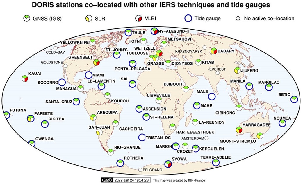
Current DORIS tracking network and co-location with other geodetic space techniques and tide gauges
The DORIS ground-tracking network has sixty operating stations geographically well distributed to meet the Precise Orbit Determination (POD) requirements. During the network development, we maintained a continuous effort to co-locate DORIS with other space geodetic technique and tide gauges. Thus, a large number of DORIS stations are co-located with GNSS stations, Satellite Laser Ranging (SLR), and Very Long Baseline Interferometry (VLBI), contributing and enhancing the development of the ITRF (International Terrestrial Reference Frame).
The DORIS ground network is composed of two types of stations: the permanent – orbitography -stations are used for POD of the current DORIS-equipped satellites in orbit, whereas the IDS stations are devoted to scientific purposes (geodesy, tectonic plates coverage, co-location, inter-calibration with other techniques) and their deployment is under the decision of the IDS Governing Board.
DORIS network goals
Serving the space altimetry missions
- Good coverage of ground stations for precise orbit determination
- Good data availability
Contributing to geodesy and geophysics
- Precise positioning of ground stations
- Co-location with other space geodetic techniques
- Long time series
Further information on DORIS System:
Station components
Indoor equipment
The beacon (4.0)
- generates two modulated signals: 401.25MHz / 2036.25MHz
- contains the reference oscillator, the frequency synthesizer, the management board, the power pack and the battery
![]()
Outdoor equipment
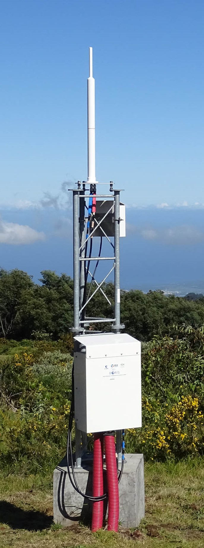
The antenna (Starec C)
- transmits the signal generated by the beacon
- is placed on very stable monument
The external MGM box
- contains a remote control system, an Iridium modem, a GPS sensor, met sensors
The external amplifier box
- contains the amplification system and a remote control system
The cables
- keep every component connected
Functional requirements
Indoor equipment: beacon
- Dedicated shelter or room or space (2 m2) for the indoor equipment
- Standard 19” equipment rack is provided by CNES
- Air conditioning system is recommended to regulate temperature and avoid moisture
- Continuous service 24/7 365 days operation
- Continuous feed and power stability is required to generate and transmit the DORIS signal
- Electric current characteristics: 100 VAC to 264 VAC voltage
- Mains frequency: 48 to 66 Hz
- In case of power failure, the maximum operating life of the DORIS battery is two hours
- The DORIS system does not require any connectivity for data transmission
Outdoor equipment: antenna
- Radiofrequency authorization from the local Authority in the host country is mandatory prior to installation of the equipment on site
- Possible RF interferences with nearby equipment must be examined prior installation and on a regular basis afterwards to prevent problems
- Maximum distance between the beacon and the antenna: 45 m
- Particular attention to the cables routing to avoid signal disruption
- Avoid very corrosive environments (e.g. excessive marine humidity)
Network distribution
- Too many stations in the same area must be avoided to prevent internal jamming between co-visible stations (Doppler collisions)
System requirements
Signal Integrity
- Antenna enclosing volume: no metal object or reflective surfaces in the antenna vicinity (5 m radius around the antenna) likely to cause multipath interference in the signal propagation (e.g. corrugated iron roofs or a slabs covered by metal-plated protection)
- Antenna visibility cone: ideally, no obstructions 5° above the horizon so as to have a clear view of the sky
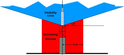
- Maintenance of a good antenna environment in the long term
Antenna monument stability
- Ground stability: avoid locations with landslides, drought-affected areas, and soft soils
- Monuments must be firmly coupled with the substrate
- Properly size the monument foundations according to the soil structure to ensure long-term stability of the antenna monument to minimize velocities uncertainty and noise in the position data
Installation
- Prior to the installation, a site reconnaissance survey will be performed by an IDS delegation to select the best suitable location for the IDS station and define a framework for the collaboration.
- The station equipment installation is undertaken by IGN-France in order to ensure smooth operation of the station and good quality position data, and perform local tie surveys.
Troubleshooting - Maintenance
- The stations maintenance relies on three teams: CNES – IGN - Local Host Agency
- Duties are clearly distributed through a tripartite agreement
- Maintaining a permanent contact between all teams is essential
- Operational failures are rare and most of the maintenance tasks are performed by CNES through the remote control system
- Presence on site (i.e. less than 30 minutes away from the beacon) of personnel qualified to carry out checks or standard maintenance operations is required
- The dispatch of equipment must be possible at least every two months, with customs clearance time shorter than two months
2. EXPECTATIONS
Attractive assets
Contribution to geographic coverage
- Ensuring the maximum percentage of visibility from the ground stations along satellites orbits over a full cycle: currently there are coverage gaps over the Pacific Ocean
- Reinforcing the network in challenging areas (Oceans, Polar Regions, Africa)
- Adding stations on secondary tectonic plates for motion monitoring: Arabian, Cocos, Filipino, Indian, Nazca
Co-location with other space geodetic techniques (GNSS – SLR – VLBI)
- Contribution to the ITRF combination
- Site surveys between each technique reference points could be carried out by IGN-France
- Inter-comparisons of local events
Co-location with tide gauges (GLOSS – PSMSL)
- Contribution to sea level variations monitoring
Co-location with absolute gravimeter
Co-location with atomic clock
Scientific collaboration expectations
The primary objective of the IDS is to provide a service to support geodetic and geophysical research activities through DORIS data and derived products.
The IDS collects, archives and distributes DORIS observation data sets of sufficient accuracy to satisfy the objectives of a wide range of applications and experimentations. From these data sets the following products are derived:
- Coordinates and velocities of the IDS tracking stations
- Geocenter and scale of the Terrestrial Reference Frame
- High accuracy ephemerides of the DORIS satellites
- Earth orientation parameters (EOPs)
The accuracies of these products are sufficient to support current scientific objectives including:
- Realization of global accessibility to, and the improvement of, the International Terrestrial Reference Frame (ITRF)
- Monitoring deformations of the solid Earth
- Monitoring crustal deformation at tide gauges
- Monitoring variations in the hydrosphere (sea level, ice-sheets, etc.)
- Orbit determination for scientific satellites
The main purpose of an IDS station is to promote scientific research. In this collaboration, results concerning the following areas are expected:
- Geodesy
- Co-location survey
- Contribution to international reference frames
- Radio Frequency Interferences Mitigation
- ….
The host agency will undertake, within its capabilities, to participate in the IDS activities - scientific papers, reviews, working groups, analysis centers – and the IDS Workshops organized every two years.
A tripartite agreement (CNES / IGN / Host Agency) will specify the framework for collaboration, the operating conditions of the station and the mutual responsibilities of the parties for the station maintenance. All parties will commit themselves for an initial period of 3 years.
3. PRACTICALITIES
Submitting a Proposal for an IDS Station
We request a short proposal (up to 5 pages, excluding references). Please include the following information in your 5-page proposal:
- Name of the host agency
- Names of the correspondents at the host agency
- Description of the research project with the IDS station
- Location of the IDS station
- Description of the facilities for hosting the DORIS beacon and antenna
- List of the geodetic instruments already in operation
- Description of the most relevant projects of research (including references) over the last four years
Please submit the proposal to the IDS Central Bureau at
Proposal evaluation
A panel of members of the IDS Governing Board will evaluate all the proposals submitted, taking into account the site compliance to the DORIS system requirements and the scientific interest of the collaboration. To aid in the deliberations, the IDS GB will solicit external reviewers to provide a scientific peer review of each proposal.
Schedule
April 27 – June 15: collection of proposals
Up to September 30: IDS feedback on the proposals
FAQ
Q: The modem of the DORIS station is Iridium. Does it have to be this type? Or can another type of modem be used?
A: The Iridium satellite constellation is used to remotely control the DORIS beacons from the DORIS Control Center in Toulouse, France. All the DORIS network stations are equipped with this remote control system in order to interpret orders (system settings) from the Control Center when necessary. It is not possible to switch to an alternate communication system. The current equipment (4th generation beacon) was designed to work with Iridium system.
