IDS's first contribution to the realization of the ITRF (International Terrestrial Reference Frame)
was the provision of individual solutions for ITRF2005 by two analysis centers (IGN, LEGOS-CLS).
Previously, DORIS solutions produced by four groups had been included in the ITRF computations:
ITRF94, ITRF96, ITRF97: contributions of CSR, GRGS and IGN
ITRF2000: contributions of AUSLIG, GRGS and IGN
Find below elements about the IDS contribution to the following ITRS realizations:
ITRF2020 | ITRF2014 | ITRF2008 | ITRF2005
The IDS 16 series is the DORIS contribution to the ITRF2020. This product is referenced with a DOI: 10.24400/312072/i01-2021.001 (follow the link to read more).
See the page: "IDS 16 - Contribution to ITRF2020"
(intially scheduled to be ITRF2013) (ITRF web page)
| Sinex Series | ||||||
| Name | grgwd40 | gscwd23 | gopwd43 | esawd10 | ignwd15 | inawd08 |
| Description form | TBD | TBD | TBD | TBD | TBD | TBD |
| Analysis Center | ||||||
| Name | CNES/ CLS | NASA/ GSFC | GOP | ESA/ ESOC | IGN | INASAN |
| Contact | H. Capdeville | F. Lemoine | P. Stepanek | M. Otten | P. Willis | S. Kuzin |
| Additionnal contacts | J.M. Lemoine, L. Soudarin | D. Chinn | N/A | N/A | N/A | S. Tatevian |
| Software | ||||||
| Name and version | GINS v 13.2d1 | GEODYN | Bernese 5.0 (DORIS development version) | NAPEOS 3.7 | GIPSY-OASIS II | GIPSY-OASIS II (v. 6.2) |
| SINEX Method (NEQ or COV) | COV | NEQ | COV | NEQ | COV | COV |
| Data weights (data reduction) | 0.3 mm/s | 2.0 mm/s (upweighted at NEQ stage, sat by sat basis) | 3 mm (range difference) | 0.5 mm/s | 0.51 mm/s for SPOT2, SPOT3, SPOT4, TOPEX, ENVISAT, CRYOSAT2; 0.4 mm/s for SPOT5, JASON2, HY2A and SARAL | 0.51 mm/s for SPOT2, SPOT3, SPOT4, TOPEX, ENVISAT, CRYOSAT2; 0.4 mm/s for SPOT5, JASON2 |
| If COV, Station Constraint | 10 m | N/A | 10 m | NEQ | 10 m | 10 m |
| If COV, EOP Constraint | 15 m | N/A | Xp, Yp 500 mas | NEQ | 5 m | 5 m |
| Satellite | ||||||
| satellites included in weekly SINEX | start-end | start-end | start-end | start-end | start-end | |
| SPOT2 | 03/01/1993 - 18/07/2009 |
03/01/1993 - 18/07/2009 |
03/01/1993 - 14/07/2009 |
03/01/1993 - 13/07/2009 |
03/01/1993 - 14/07/2009 |
03/01/1993 - 14/07/2009 |
| SPOT3 | 30/01/1994 - 16/11/1996 |
30/01/1994 - 16/11/1996 |
01/02/1994 - 12/11/1996 |
02/02/1994 - 12/09/1996 |
02/02/1994 - 14/11/1996 |
01/02/1994 - 13/11/1996 |
| SPOT4 | 03/05/1998 - 22/06/2012 |
03/05/1998 - 31/12/2012 |
10/05/1998 - 22/06/2013 |
03/05/1998 - 24/06/2012 |
01/05/1998 - 18/06/2013 |
01/05/1998 - 23/06/2013 |
| SPOT5 | 16/06/2002 - 27/12/2014 |
16/06/2002 - 31/12/2012 |
16/06/2002 - 30/08/2014 |
17/06/2002 - 31/12/2013 |
11/06/2002 - 31/12/2013 |
11/06/2002 - 31/12/2013 |
| TOPEX | 03/01/1993 - 30/10/2004 |
03/01/1993 - 30/10/2004 |
03/01/1993 - 30/10/2004 |
03/01/1993 - 31/10/2004 |
01/01/1993 - 01/11/2004 |
03/01/1993 - 01/11/2004 |
| ENVISAT | 21/07/2002 - 07/04/2012 |
21/07/2002 - 07/04/2012 |
21/07/2002 - 07/04/2012 |
21/07/2002 - 07/04/2012 |
11/04/2002 - 08/04/2012 |
02/06/2002 - 08/04/2012 |
| JASON1 | 31/10/2004 - 12/07/2008 |
31/10/2004 - 12/07/2008 |
N/A | TBD | N/A | N/A |
| JASON2 | 13/07/2008 - 27/12/2014 |
13/07/2008 - 31/12/2012 |
13/07/2008 - 30/08/2014 |
14/07/2008 - 31/12/2013 |
12/07/2008 - 31/12/2013 |
12/07/2008 - 31/12/2013 |
| CRYOSAT2 | 20/06/2010 - 27/12/2014 |
20/06/2010 - 31/12/2012 |
30/05/2010 - 30/08/2014 |
30/05/2010 - 31/12/2013 |
30/05/2010 - 31/12/2013 |
30/05/2010 - 31/12/2013 |
| HY2A | 02/10/2011 - 27/12/2014 |
TBD | 01/01/2012 - 30/08/2014 |
02/10/2011 - 31/12/2013 |
01/10/2011 - 31/12/2013 |
N/A |
| SARAL | 17/03/2013 - 27/12/2014 |
TBD | N/A | TBD | 15/03/2013 - 31/12/2013 |
N/A |
| Arc cut | ||||||
| Arc lengths | 3.5 days nominally (minimum 1 day) | 7.0 days, typically | 1 day | 1 day | 1 day | 1 day |
| Handle of Manoeuvers | Break arc and Restart at 12am or 12pm; estimated from 2012/01/01 | Truncate arc before maneuver. Restart 1-2 hrs afterward. | daily arc not processed | Included for all satellites with manoeuvre info, others excluded for that day | Break arc and start or end at 12:00 | Break arc and start or end at 12:00 |
| Handle of Data gaps | Arcs truncated for large data gaps and Restarted. | Arcs truncated for large data gaps and restarted. | daily arcs with large data gaps not processed | Nothing | daily arcs with large data gaps not processed | daily arcs with large data gaps not processed |
| Additional margins | 6hrs before and 6 hrs after for POD but not in SINEX | None | None | None | 3hrs before and 3 hrs after for POD but not in SINEX | 3hrs before and 3 hrs after for POD but not in SINEX |
| Reference System | ||||||
| Earth reference system | DPOD2008v12 | DPOD2008v12 | DPOD2008v12 | DPOD2008v12 | DPOD2008 v1.13 | DPOD2008 v1.13 |
| Celestial reference system | inertial J2000 | inertial J2000 | inertial J2000 | inertial J2000 | inertial J2000 | inertial J2000 |
| Polar motion and UT1 | IERS C04 08 | IERS C04 | IERS C04 | IERS C04 08 | IERS Bulletin A | IERS Bulletin A |
| Background C21, S21 | IERS 2010 (Equation 6.5, Petit and Luzum, 2010) | IERS 2010 Conventions | IERS 2010 (Equation 6.5, Petit and Luzum, 2010) | IERS 2003 | IERS 2003 | |
| Pole model | IERS 2010, (Table 6.6, Petit & Luzum, 2010) | IERS 2010 Conventions | IERS 2010, (Table 6.6, Petit & Luzum, 2010) | IERS 2010 | IERS 2010 | |
| Precession/Nutation | IERS 2010 using NRO origin | IERS 2003 | IERS 2003 | IERS 2010 | IERS 2010 | IERS 2010 |
| Station coordinates | DPOD2008v12 | DPOD2008v12 | DPOD2008v12 | DPOD2008v12 | DPOD2008 v1.13 | DPOD2008 v1.13 |
| Displacement of reference points | ||||||
| Solid Earth tidal displacement | IERS 2010 Conventions | IERS 2010 Conventions | IERS 2010 Conventions | IERS 2010 Conventions | IERS 2010 Conventions | IERS 2010 Conventions |
| Ocean loading | FES 2012 | GOT4.8 | FES 2004 | EOT11a | FES 2004 | FES 2004 |
| Tidal atmospheric loading | S1/S2 Ray & Ponte (2003) | none | N/A | S1/S2 Ray & Ponte (2003); Also P1, K1; T2, R2. | not applied | not applied |
| Non tidal atmospheric loading | none | not applied | N/A | none | not applied | not applied |
| Solid pole tide displacement | IERS 2010 Conventions | IERS 2010 Conventions | IERS 2010 Conventions | IERS 2010 Conventions | IERS 2010 Conventions | IERS 2010 Conventions |
| Ocean pole tide displacement | none | Applied. | N/A | not applied | applied | applied |
| Tidal Geocenter | Applied, GOT4.7 | N/A | ||||
| Satellite reference | ||||||
| Mass and center of gravity | initial values and time evolution from IDS files "sat"mass.txt | Initial values and time history from IDS files. | Initial values from IDS files | Initial values and time history from IDS files. | Initial values and time history from IDS files | Initial values and time history from IDS files |
| Attitude Model | nominal laws | Attitude model, generally; Quaternions for off-nominal TOPEX arcs; Quaternions for Jason-1, Jason-2. Ejo/TU Delft quaternions for Cryosat-2 | nominal laws, GSC tunned for SPOTs | nominal laws | nominal laws | nominal laws |
| Gravity | ||||||
| Gravity field (static) | EIGEN-6S2 | GOCO02s | EIGEN-6S2 after 2002.0, EIGEN-GL04S1 before 2002.0 | EIGEN-6S2 | EIGEN-6S2.extended.v2.gfc | GOCO2S |
| Gravity field (time varying) | EIGEN-6S2 up to degree 95 including time variable terms up to degree 50 (bias & drift per yr from 2002 to 2012, periodic 18.6, 1, 0.5yrs) | (1) to 5x5 - fit to SLR,DORIS time series; (2) > 5x5. Annual terms from GSFC-derived GRACE solutions. | EIGEN-6S2 after 2002.0,var. terms up to deg. 50. No harmonic terms before 2002.0 | EIGEN-6S2 up to degree 120 including time variable terms up to degree 50 (bias & drift per yr from 2002 to 2012, 1, 0.5yrs) | from EIGEN-6S2.extended.v2.gfc | (1) to 4x4 - fit to SLR,DORIS time series; (2) > 4x4. Annual terms from GSFC-derived GRACE solutions |
| Solid Earth tides | IERS 2010 conventions | IERS 2003 | IERS 2010 conventions | IERS 2010 conventions | IERS 2010 | IERS 2010 |
| Ocean tides | FES 2012 (32 principal waves, + 60 admittance waves) up to degree 50 | GOT4.8 | FES 2004 | EOT11a up to degree order 50 | FES 2004 | FES 2004 |
| Atmospheric gravity | 3hr ERA-interim / ECMWF up to degree 50 | ECMWF-6hr (Re-analysis) to 50x50 | ECMWF-6hr up to 20X20 | AGRA-6hr to 20x20 | not applied | not applied |
| Air Tides | Ray and Ponte (2003), S1, S2; K1, P1, R2, T2 | |||||
| Non tidal oceanic gravity | TUGO R12 up to degree 50 TUGO R12 up to degree 50 | N/A | N/A | N/A | not applied | not applied |
| Atmospheric tides | none (considered through the ECMWF atmospheric data) | Terms removed from ECMWF fields applied separately | N/A | none | not applied | not applied |
| Earth pole tide | IERS 2010 conventions | IERS 2010 Conventions | IERS 2010 Conventions | IERS 2010 Conventions | IERS 2010 Conventions | IERS 2010 Conventions |
| Ocean pole tide | Desai 2002 up to degree 12 | Desai, 2002. Applied to 50x50 | C21, S21 IERS Conventions 2010 | IERS 2010 Conventions | IERS 2010 Conventions | IERS 2010 Conventions |
| Third bodies | Sun, Moon, Mars, Venus, Jupiter, Saturn, Uranus and Neptune ephemeris : DE421 (JPL) | Sun, Moon, Planets: DE403 (JPL) | Sun, Moon, Major Planets DE405 | Sun, Moon, Planets: DE405 (JPL) | Sun, Moon, Planets: DE421 (JPL) | Sun, Moon, Planets: DE421 (JPL) |
| Surface forces and empiricals | ||||||
| Radiation Pressure model | Thermo-optical coefficient from pre-launch box and wing model, with smoothed Earth shadow model; models from CNES document for all satellites except tuned macromodels for Spot-2, -3, -4, Jason2 | SPOT-2, SPOT-3: Macromodel Updated from LeBail et al. (2010); SPOT-4: LeBail et al. (2010); SPOT-5: Le Bail et al. (2010) + variable solar array pitch modelled after January 2008; Cryosat2: CNES (7plate) macromodel; Jason-2: CNES (Modified macromodel); TOPEX: Marshall et al. (1995), Marshall and Luthcke (1994); University of College London (UCL) models for Jason-1, and Envisat. | Thermo-optical coefficient from pre-launch box and wing model, with smoothed Earth shadow model; models from CNES document for all satellites except tuned macromodels for Spot-2, -3, -4 | CNES model for all satellites except for Jason-1/2 (tuned), TOPEX (GSFC values) and Enivsat (ANGARA model) | CNES model for all satellites except for Jason-2 (tuned) and Cryosat2 (modified CNES 7plate macromodel) | CNES model for all satellites except for Jason-2 (tuned) and Cryosat2 (modified CNES 7plate macromodel) |
| Radiation pressure scale coefficient | 1 coef/day but strongly constrainted (1. e-4) to: 1.03 for Topex; 1.07 for Spot-2; 1.07 for Spot-3; 1.16 for Spot-4; 1.05 for Spot-5; 1.05 for Envisat; 0.94 for Jason-1, 0.97 for Jason-2; 1.00 for Cryosat-2; 0.86 for HY-2A; 1.00 for Saral | Cr=1.00 for satellites except, For Jason-2: Cr= 0.945; For Envisat Cr=1.0041747; | 1 coeff/day. First iteration without 1-rev parameters, in second iteration constrained (1.e-1) | fixed, TOPEX 1.03 SPOT-2/3 1.08 SPOT-4 0.98 SPOT-5 1.04 JASON-1 1.0 JASON-2 0.98 ENVISAT 0.98 CRYOSAT-2 1.0 HY-2A 1.0 | fixed: TOPEX 1.03; SPOT-2/3 1.08; SPOT-4 1.13; SPOT-5 1.03; JASON-2 0.92; ENVISAT 1.02; CRYOSAT2 1.05; SARAL 1.08; HY2A 0.88 | fixed: TOPEX 1.03; SPOT-2/3 1.08; SPOT-4 1.13; SPOT-5 1.03; JASON-2 0.92; ENVISAT 1.02; CRYOSAT2 1.05 |
| Earth radiation | Albedo and IR pressure values interpolated from ECMWF 6hr grids | Knocke et al. (1988) | apriori model using CERES data | Monthly mean Albedo and IR maps at 2.5x2.5 degrees | Albedo correction applied | Albedo correction applied |
| Atmospheric density model | DTM 94, with best available solar activity | MSIS86 | MSIS86 | MSIS2000 | DTM94 | DTM2000 |
| Drag coefficients | Adjusted; Spots, Envisat, Cryosat2, HY-2A, Saral: 1 coef/4 hours (1/1hr in high solar activity periods) ; Topex,Jasons: 1 coef/half day | Cd/8hrs (TOPEX, Jason-1, Jason-2); Cd/1-2 hrs for 800-km satellites depending on solar flux. | adjusted 1 coeff./30 minutes for 800-km atellites, 1 coeff./6 hours for others | TOPEX, Jason 4 a day rest 10 drag coefficients a day | Cd/8hrs (TOPEX, Jason-2); Cd/1hr for SPOT-2,3,4,5, ENVISAT, CRYOSAT2, HY2A and SARAL | Cd/8hrs (TOPEX, Jason-2); Cd/1hr for SPOT-2,3,4,5, ENVISAT, CRYOSAT2 |
| 1/rev empiricals | 2 coeff cos-sin /orbital period in normal direction ; 2 coeff cos-sin /orbital period in tangential direction ; per arc | Opr/day along+ cross-track | Opr/day along (cross not adjusted) | Opr/day along+ cross-track | Opr/day along + cross-track | Opr/day along + cross-track |
| DORIS measurements | ||||||
| Troposphere Model | GPT2/VMF1 | Saastamoinen | Saastamoinen | Saastamoinen | none | none |
| Weather (meteorological data) | GPT | GPT | GPT | not used | not used | |
| Troposphere mapping function | GMF | GMF | GMF | VMF1 | GMF | |
| Troposphere correction | One zenith delay/pass (wet tropo scale factor adjusted) + one daily tropospheric gradient per station in North & East directions | Scale factor/pass estimated for wet correction only. | One zenith delay/pass (wet tropo scale factor adjusted) | One zenith delay/pass (wet tropo scale factor adjusted) + one daily tropospheric gradient per station in North & East directions | wet tropospheric delay estimated per station with reset for some passes only if separated by more than 20 minutes | wet tropospheric delay estimated per station with reset for some passes only if separated by more than 20 minutes |
| 2nd order ionosphere | Not applied | Not applied | N/A | Not applied | Not applied | Not applied |
| Frequency | 1 frequency bias adjusted per pass | Range-rate bias adjusted/pass; Change in nominal beacon frequency accommodated with modification of partial derivatives. | 1 frequency bias adjusted per pass | Range-rate bias adjusted/pass; Change in nominal beacon frequency accommodated with modification of partial derivatives. | 1 frequency bias adjusted per station clock if separated by more than 20 minutes + 1 frequency bias per satellite clock (except 1) if separated by more than 20 minutes | 1 frequency bias adjusted per station clock if separated by more than 20 minutes + 1 frequency bias per satellite clock (except 1) if separated by more than 20 minutes |
| Relativity | Schwarzschild model + Lense-Thirring + geodesic precession | Schwarzschild model + Lense thirring + geodesic precession | Schwarzschild model + Lense-Thirring + geodesic precession | Schwarzschild model + Lense thirring + geodesic precession | Schwarzschild model + Lense-Thirring + geodesic precession | Schwarzschild model + Lense-Thirring + geodesic precession |
| Weight | models: 0.3 mm/s; measurements: derived from observation standard deviation in data files | 2 mm/s. upweighted per satellite at NEQ level. | 3 mm (range difference) | 0.5mm/s | 0.51 mm/s for SPOT2, SPOT3, SPOT4, TOPEX, ENVISAT, CRYOSAT2; 0.4 mm/s for SPOT5, JASON2 , HY2A and SARAL | 0.51 mm/s for SPOT2, SPOT3, SPOT4, TOPEX, ENVISAT, CRYOSAT2; 0.4 mm/s for SPOT5, JASON2 |
| Elevation angle cutoff | 12 degrees | 10 degrees | 10 degrees | 7 degrees | 7 degrees | 12 degrees |
| Downweighting law | Downweighting law for elevation <= 20 deg; Weight of the observation is multiplied by the factor elevation**2/400 with elevation in degrees) | none | none | TBD (currently sin(elevation) after 2002) | 1/sqrt(sin(elevation)) | 1/sin(elevation) |
| Satellite system | Center of mass - antenna phase center vector computed from macro model + attitude law; no phase law applied | tracking point offset applied using offset information and attitude law and quaternions for spacecraft. | Center of mass - antenna phase center vector computed from macro model + attitude law; no phase law applied | Center of mass - antenna phase center vector computed from macro model + attitude law; no phase law applied | Center of mass - antenna phase center vector computed from macro model + attitude law; no phase law applied | Center of mass - antenna phase center vector computed from macro model + attitude law; no phase law applied |
| Ground system | Phase centre / reference point vector from manufacturer values; phase law applied (Alcatel, Starec version 2013) | Phase correction + vertical eccentricity applied in GEODYN or through modification of DPOD2008v12 station coordinates | Phase centre / reference point vector from manufacturer values; phase law applied (Alcatel, Starec version 2013) | Phase centre / reference point vector from manufacturer values; phase law applied (Alcatel, Starec) | Phase centre / reference point vector from manufacturer values; phase law not applied (Alcatel, Starec) | |
| DORIS System Time Bias | Model applied for TOPEX/Poseidon derived from SLR-DORIS arcs. | N/A | no bias correction applied to satellite clock | |||
| South Atlantic Anomaly | Corrective model for Jason-1; corrected measurements for Spot-5 from 2006 only | Corrective model applied for Jason-1; Corrective model applied for SPOT-5 (2006.0 - onward) | Corrected measurements for Spot-5 (2006.0 - onward). Jason-1 data not used at all | Corrective model for Jason-1; corrected measurements for Spot-5 from 2006 only | Jason-1 data not used at all; corrective model applied for SPOT-5 (2006.0 - onward) . A few stations removed for SPOT-5 data (Arequipa, Cachoeira, Easter Island, Kourou) | Jason-1 data not used at all; corrective model applied for SPOT-5 (2006.0 - onward) |
(First iteration Feb. 2009) (Last iteration Nov. 2009)
The IDS-3 SINEX time series may be downloaded at documents/BC/combinations/ITRF2008-IDS/IDS-3/
ITRF2008 Call
Two IDS Analysis Working Group meetings have been organized in March and June 2008 in Paris, Bureau des Longitudes, and an IDS workshop in Nice, 12-14 November 2008. Eight DORIS analysis centers participated including four official analysis centers (IGN; LCA ; GOP ; ESA), and four candidate analysis centers (NCL - University of Newcastle; GAU - Geoscience Australia; INA - Institute of Astronomy, Russian Academy of Sciences, and GSC - NASA Goddard Space Flight Center). All these centers are working to provide SINEX solutions for inclusion in the IDS combined solution that will be submitted to the IERS for ITRF2008.
This is an important step for IDS Analysis centers! Indeed for ITRF2005, only two individual DORIS solutions were included: IGN and LCA. A main goal was to improve the models and processing strategies of the new ACs, to discuss the standards and to get ready for the IDS contribution to ITRF2008.
The IDS Analysis Centers are listed hereafter. Analysis activities are coordinated by F. Lemoine.
| Analysis Center | Acron. | Contact |
| Geodetic Observatory of Pecny, Czech Republic | gop | Petr Stepanek |
| Institute of Astronomy, Russian Academy of Sciences (INASAN), Russia | ina | Sergey Kuzin Surya Tatevian |
| CNES/CLS, France | lca | Laurent Soudarin Hugues Capdeville Jean-Michel Lemoine |
| IGN/IPGP, France | ign | Pascal Willis Marie-Line Gobinddass |
| ESA/ESOC, Germany | esa | Michiel Otten |
| Geoscience Australia, Australia (with support of GSFC) |
gau | Ramesh Govind Frank Lemoine |
| GSFC, USA | gsc | Frank Lemoine |
| University of Newcastle, UK | ncl | Philip Moore |
The IDS combinations of weekly solutions for the station coordinates and the Earth Orientation Parameters are realized with CATREF, the IGN/LAREG Software.
| Coordination Center | Acron. | Contact |
| CLS/CNES | ids (TBC) | Jean-Jacques Valette Philippe Yaya Pascale Ferrage |
| LAREG/IGN (software and strategy support) | - | Zuheir Altamimi |
The following table summarizes the AC submissions and associated main models as well as the DORIS SINEX series provided for the contribution to ITRF2008.
See also the DORIS satellites constellation history status.
| AC | Software | Sol. Id. | Type (1) | Data span | Satellites (2) | Earth Gravity Field |
Constraint | EOPs | Desc. |
| gop | BERNESE 5.0 | wd31 | var-cov | 1999.0-2006.9 | Spot 2/4/5 Topex Envisat Jason-1 in 2002 |
EIGEN-GL04S annual, 100X100 | loose | motion, rate | dsc more |
| ina | GYPSY/OASIS 4.03 | wd03 | var-cov | 1997.0-2008.8 | Spot 2/5 Spot 4 (except 05/98-01/99) Topex Envisat |
GGM01C fixed, 120x120 |
loose | motion rate (constrained) LOD, UT1 |
dsc more |
| lca | GINS/DYNAMO | wd20 | var-cov | 1993.0-1998.4 1999.4-2002.0 2002.0-2008.0 |
Spot 2/3/4/5 Topex & Envisat (Topex/Envisat orbits with SLR) |
EIGEN_GL04S drift, annual semi-annual 95x95 |
loose | motion | dsc readme more |
| ign | GYPSY/OASIS 5.0 | wd08 | var-cov | 1993.0-2008.8 | Spot 2/3/4/5 Topex Envisat |
GGM03S fixed, 120x120 |
loose | motion rate (constrained) LOD, UT1 |
dsc readme more |
| gau | GEODYN | wd06 | var-cov | 2003.0-2008.8 | Spot 2/4/5 Envisat Jason-1 |
GGM02C annual, 160x160 |
loose | motion UT1 |
dsc more |
| esa | NAPEOS | wd01 | NEQ | 1998.0-2008.0 | Spot 2/4/5 Envisat (Envisat orbits with SLR) |
EIGEN-GL05C | loose | motion, rate LOD |
dsc more |
(1) var-cov: variance-covariance, NEQ: Normal Equation
(2) Specific recommendation for Jason-1 is to exclude Jason-1 data after 2003 because of the USO sensitivity to SAA (cf AWG-June 2008)
The delivered SINEX are not yet fully compliant with the IERS call for participation requirements. The non compliant items are the followings:
Concerning the last issue, LCA will provide a new SINEX series for which the weekly mean value of the atmospheric loading correction is removed.
The preprocessing of the SINEX solutions is realized per AC series and includes the following steps:
| gop | ina | lca | ign | esa | gau | gsc | ncl | |
| vs ITRF2005 | t7p-I05 | t7p-I05 | t7p-I05 | t7p-I05 | t7p-I05 | t7p-I05 | t7p-I05 | |
| Internal Coherency | T7p-IC | T7p-IC | T7p-IC | T7p-IC | T7p-IC | T7p-IC | ||
| Report | sum | sum | sum | sum | sum | sum | sum | sum |
| Residuals |
(to be completed)
The weekly combination results from a 7-parameter transformation calculated every week using an IDS ITRF2005 datum . This datum results from a selection of DORIS stations having the best on position (< 1 cm) and velocity (< 2 mm/yr), and included in the week solution to be processed. For each week, the steps are as follows:
Note that at least 3 solutions are needed to generate a weekly combined solution. That is to say that a combination is possible over the 1997.0-2008.8 period.
Combination results (under construction)
IDS recommendations (Pascal Willis, Laurent Soudarin, Herve Fagard, John Ries, Ron Noomen) Version 1.0 November 15, 2005
This document is supplemented by the following files:
ids_station_breaks.txt [text file]: list of epochs of discontinuities in DORIS stations (in ITRF format)
ids_period_to_delete.txt [text file]: list of DORIS observation periods that should be disregarded (in ITRF format)
ids_core_evolution.mov [movie] evolution in time of the proposed DORIS core network (in one or more movie formats).
IDS for ITRF2004 (Pascal Willis, Laurent Soudarin, Herve Fagard, John Ries, Ron Noomen) Version 1.0 November 15, 2005
This document is supplemented by the following files:
ids_station_breaks.txt [text file]: list of epochs of discontinuities in DORIS stations (in ITRF format)
ids_period_to_delete.txt [text file]: list of DORIS observation periods that should be disregarded (in ITRF format)
ids_core_evolution.mov [movie] evolution in time of the proposed DORIS core network (in one or more movie formats).
Latest update: March 2, 2014
DPOD2008
Terrestrial reference frame for precise orbit determination
derived from ITRF2008
Description of earlier work (DPOD2005) can be found in Willis, P., Ries, J.C., Zelensky, N.P., Soudarin,, L., Fagard, H., Pavlis, E.C., Lemoine, F.G. (2009) DPOD2005, an extension of ITRF2005 for precise orbit determination, Advances in Space Research, 44(5), 535-544, DOI: 10.1016/j.asr.2009.04.018
This reference is suggested for citation purposes:
Willis, P., Zelensky, N.P., Ries, J., Soudarin, L., Cerri, L., Moreaux, G., Lemoine, F.G., Otten, M., Argus, D.F., Heflin, M.B. (2016) DPOD2008, a DORIS-oriented Terrestrial Reference Frame for Precise Orbit Determination, IAG SYMPOSIA SERIES,143, 175-181, DOI : 10.1007/1345_2015_125.
This work is being conducted by the following indiviuals (by alphabetical order): Donald F. Argus (Jet Propulsion Laboratory, USA), Luca Cerri (CNES, France), Mike B. Heflin (Jet Propulsion Laboratory, USA), Frank G. Lemoine (NASA/GSFC, USA), Guilhem Moreaux (CLS, France), Michiel Otten (ESOC, Germany) John C. Ries (UT/CSR, USA), Laurent Soudarin (CLS, France),
Access to DPOD2008 (latest version = 1.14): text format or SINEX format
Differences with earlier versions
In the following Table, we use the following conventions:
- more details can be obtained for any specific station in blue in the left column
- this Table only displays the number of discontinuities (in position and/or in velocities) as well as the number of periods for which data should not be used for precise orbit determination. More details can be obtained in the DPOD2008 file (see above)
- as integrity is an important factor for DPOD2008, coordinates/velocities are first proposed by a member of the group (status is then TBC = To be confirmed). When this information is confirmed by at least another member of the group, is possible using an independent approach, coordinates and velocities are then considered as final (X). Otherwise, when DORIS coordinates and velocities are not yet available, the following convention is used: TBD (To be done).
|
Acronym |
Active (after 2009) |
DPOD2008 status |
Discontinuity (position) |
Discontinuity (velocity) |
Data to be deleted |
Source
|
Reason for exclusion from ITRF2008 |
|
ADEA |
N |
OK |
|
|
|
ITRF2008 |
|
|
ADEB |
N |
OK |
|
|
|
ITRF2008 |
|
|
N |
OK |
|
|
|
ADFB |
But add period for bad data |
|
|
Y |
OK |
|
|
|
ADFB |
Not in ITRF2008 |
|
|
N |
OK |
|
|
|
DORIS |
Not in ITRF2008 |
|
|
AMSA |
N |
OK |
|
|
1 |
ITRF2008 |
|
|
AMSB |
N |
OK |
|
|
1 |
ITRF2008 |
|
|
AMTB |
N |
OK |
1 |
|
|
ITRF2008 |
|
|
AMUB |
N |
OK |
|
|
|
ITRF2008 |
|
|
Y |
OK |
|
|
|
AMUB |
Not in ITRF2008 |
|
|
N |
OK |
|
|
|
DORIS |
Possible SAA problem |
|
|
N |
OK |
|
|
|
DORIS |
Possible SAA problem |
|
|
Y |
OK |
|
|
|
DORIS |
Possible SAA problem |
|
|
N |
OK |
|
|
|
DORIS |
Velocity formal error |
|
|
N |
OK |
|
|
|
DORIS |
Velocity formal error |
|
|
N |
OK |
|
|
|
ITRF2008 |
After checking break / data gap |
|
|
Y |
OK |
|
|
|
ASDB |
Not in ITRF2008 |
|
|
BADA |
N |
OK |
|
|
|
ITRF2008 |
|
|
BADB |
Y |
OK |
|
|
|
ITRF2008 |
|
|
BELB |
N |
OK |
|
|
|
ITRF2008 |
|
|
BEMB |
Y |
OK |
|
|
|
ITRF2008 |
|
|
Y |
OK |
|
|
|
DORIS |
Not in ITRF2008 |
|
|
N |
OK |
|
|
1 |
DORIS |
Possible SAA problem |
|
|
Y |
OK |
1 |
|
|
DORIS |
Possible SAA problem + break |
|
|
CARB |
N |
OK |
|
|
|
Do not use |
Not in ITRF2008 |
|
CHAB |
Y |
OK |
|
|
|
ITRF2008 |
|
|
CIBB |
N |
OK |
|
|
|
ITRF2008 |
|
|
CICB |
N |
OK |
|
|
|
ITRF2008 |
|
|
Y |
OK |
|
|
|
DORIS |
Not in ITRF2008 |
|
|
N |
OK |
|
|
|
DORIS |
Deleting 2 breaks |
|
|
Y |
OK |
|
|
|
DORIS |
Not in ITRF2008 |
|
|
CROB |
N |
OK |
|
|
|
ITRF2008 |
|
|
CRPB |
N |
OK |
|
|
|
ITRF2008 |
|
|
Y |
OK |
|
|
|
DORIS |
Not in ITRF2008 |
|
|
DAKA |
N |
OK |
|
|
|
ITRF2008 |
|
|
N |
OK |
|
|
1 |
DORIS |
Deleting break |
|
|
Y |
OK |
|
|
|
DORIS |
Deleting break |
|
|
N |
OK |
|
|
|
Do not use |
Not in ITRF2008 |
|
|
N |
OK |
|
|
|
ITRF2008 |
|
|
|
Y |
OK |
|
|
|
DORIS |
Deleting 2 breaks |
|
|
EASA |
N |
OK |
|
|
|
ITRF2008 |
|
|
EASB |
Y |
OK |
|
|
|
ITRF2008 |
|
|
Y |
OK |
1 |
|
1 |
DORIS |
Deleting break |
|
|
N |
OK |
|
|
|
DORIS |
Velocity formal error |
|
|
Y |
OK |
2 |
|
|
DORIS |
Velocity formal error |
|
|
N |
OK |
|
|
|
DORIS |
Not in ITRF2008 |
|
|
FUTB |
N |
OK |
|
|
|
ITRF2008 |
|
|
Y |
OK |
|
|
|
FUTB |
Not in ITRF2008 |
|
|
GALA |
N |
OK |
|
|
|
ITRF2008 |
|
|
Y |
TBC |
|
|
|
DORIS |
Velocity formal error |
|
|
GOLA |
N |
OK |
|
|
|
ITRF2008 |
|
|
GOMA |
N |
OK |
|
|
|
ITRF2008 |
|
|
GOMB |
N |
OK |
|
|
1 |
ITRF2008 |
|
|
GR2B |
N |
OK |
|
|
|
do not use |
Not in ITRF2008 |
|
N |
OK |
|
|
|
SLR |
Not in ITRF2008 |
|
|
Y |
OK |
|
|
|
GR3B |
Not in ITRF2008 |
|
|
GREB |
N |
OK |
|
|
|
ITRF2008 |
|
|
Y |
OK |
|
|
|
SIMB |
Not in ITRF2008 |
|
|
GUAB |
N |
OK |
|
|
|
ITRF2008 |
|
|
HBKA |
N |
OK |
|
|
|
ITRF2008 |
|
|
HBKB |
N |
OK |
|
|
|
ITRF2008 |
|
|
HBLA |
N |
OK |
|
|
|
ITRF2008 |
|
|
N |
OK |
|
|
|
DORIS |
Not in ITRF2008 |
|
|
HBMB |
Y |
OK |
|
|
|
ITRF2008 |
|
|
N |
OK |
|
|
1 |
ITRF2008 |
|
|
|
N |
OK |
|
|
1 |
DORIS |
Deleting break |
|
|
HEMB |
N |
OK |
|
|
|
ITRF2008 |
|
|
N |
OK |
|
|
|
DORIS |
Not in ITRF2008 |
|
|
N |
OK |
|
|
1 |
DORIS |
Not in ITRF2008 |
|
|
N |
OK |
|
|
|
DORIS |
Not in ITRF2008 |
|
|
JIUB |
N |
OK |
|
|
|
ITRF2008 |
|
|
Y |
OK |
|
|
|
DORISMail |
Not in ITRF2008 |
|
|
N |
OK |
|
|
1 |
ITRF2008 |
|
|
|
N |
OK |
|
|
|
ITRF2008 |
|
|
|
N |
OK |
|
|
|
DORIS |
Deleting break |
|
|
Y |
OK |
|
|
|
ITRF2008 |
|
|
|
KITA |
N |
OK |
|
|
|
ITRF2008 |
|
|
KITB |
N |
OK |
|
|
|
ITRF2008 |
|
|
KIUB |
Y |
OK |
|
|
|
ITRF2008 |
|
|
KOKA |
N |
OK |
|
|
|
ITRF2008 |
|
|
KOLB |
Y |
OK |
|
|
|
ITRF2008 |
|
|
N |
OK |
|
|
1 |
DORIS |
Velocity formal error |
|
|
Y |
OK |
|
|
|
KRAB |
Not in ITRF2008 |
|
|
N |
OK |
|
|
|
DORIS |
Not in ITRF2008 |
|
|
N |
OK |
2 |
2 |
|
DORIS |
After checking SAA effect + 2 breaks |
|
|
N |
OK |
2 |
2 |
|
DORIS |
After checking SAA effect + 2 breaks |
|
|
Y |
OK |
|
|
|
KRUB |
Not in ITRF2008 |
|
|
Y |
OK |
|
|
|
DORISMail |
Not in ITRF2008 |
|
|
LIBA |
N |
OK |
|
|
|
ITRF2008 |
|
|
LIBB |
N |
OK |
|
|
|
ITRF2008 |
|
|
LICB |
Y |
OK |
|
|
|
ITRF2008 |
|
|
N |
OK |
|
|
|
DORIS |
Not in ITRF2008 |
|
|
MAHB |
N |
OK |
|
|
|
ITRF2008 |
|
|
Y |
TBC |
|
|
|
DORISMail |
Not in ITRF2008 |
|
|
MALB |
Y |
OK |
|
|
|
ITRF2008 |
|
|
MANA |
N |
OK |
|
|
|
ITRF2008 |
|
|
MANB |
Y |
OK |
1 |
|
1 |
ITRF2008 |
|
|
MARA |
N |
OK |
|
|
|
ITRF2008 |
|
|
MARB |
N |
OK |
1 |
|
1 |
ITRF2008 |
|
|
MATB |
Y |
OK |
1 |
|
1 |
ITRF2008 |
|
|
META |
N |
OK |
|
|
|
ITRF2008 |
|
|
METB |
N |
OK |
|
|
|
ITRF2008 |
|
|
Y |
OK |
|
|
|
DORISMail |
Not in ITRF2008 |
|
|
MIAB |
Y |
OK |
|
|
|
ITRF2008 |
|
|
MONB |
N |
OK |
|
|
|
ITRF2008 |
|
|
MOOB |
Y |
OK |
|
|
|
ITRF2008 |
|
|
MORA |
N |
OK |
|
|
|
ITRF2008 |
|
|
MORB |
N |
OK |
1 |
|
1 |
ITRF2008 |
|
|
Y |
TBC |
|
|
|
DORISMail |
Not in ITRF2008 |
|
|
Y |
OK |
|
|
1 |
ITRF2008 |
Discontinuity checked |
|
|
Y |
OK |
|
|
|
ITRF2008 |
Discontinuity checked |
|
|
NOUA |
N |
OK |
|
|
|
ITRF2008 |
|
|
NOUB |
N |
OK |
|
|
|
ITRF2008 |
|
|
NOWB |
N |
OK |
|
|
|
ITRF2008 |
|
|
Y |
OK |
1 |
1 |
|
NOWB |
Not in ITRF2008 |
|
|
ORRA |
N |
OK |
|
|
|
ITRF2008 |
|
|
ORRB |
N |
OK |
|
|
|
ITRF2008 |
|
|
N |
OK |
|
|
1 |
DORIS |
Not in ITRF2008 |
|
|
N |
OK |
|
|
|
DORIS |
Not in ITRF2008 |
|
|
PAPB |
N |
OK |
|
|
|
ITRF2008 |
|
|
PAQB |
N |
OK |
|
|
|
ITRF2008 |
|
|
N |
OK |
|
|
|
DORIS |
Not in ITRF2008 |
|
|
PATB |
N |
OK |
|
|
|
ITRF2008 |
|
|
Y |
OK |
|
|
|
PATB |
Not in ITRF2008 |
|
|
PDLB |
N |
OK |
|
|
|
ITRF2008 |
|
|
PDMB |
Y |
OK |
|
|
1 |
ITRF2008 |
OK After deleting break |
|
PURA |
N |
OK |
|
|
|
ITRF2008 |
|
|
RAQB |
N |
OK |
|
|
|
ITRF2008 |
|
|
REUA |
N |
OK |
|
|
|
ITRF2008 |
|
|
N |
OK |
|
|
1 |
DORIS |
Deleting break |
|
|
N |
OK |
|
|
|
DORIS |
Velocity formal error |
|
|
N |
OK |
|
|
|
DORIS |
Velocity formal error |
|
|
Y |
OK |
|
|
|
DORIS |
Velocity formal error |
|
|
N |
OK |
|
|
|
DORIS |
Not in ITRF2008 |
|
|
RIDA |
N |
OK |
|
|
|
ITRF2008 |
|
|
N |
OK |
1 |
|
|
DORIS |
Not in ITRF2008 |
|
|
N |
OK |
|
|
|
DORIS |
Not in ITRF2008 |
|
|
Y |
OK |
|
|
|
RILB |
Not in ITRF2008 |
|
|
N |
OK |
|
|
1 |
ITRF2008 |
|
|
|
RIOB |
N |
OK |
|
|
|
ITRF2008 |
|
|
RIPB |
N |
OK |
1 |
|
|
ITRF2008 |
|
|
RIQB |
N |
OK |
|
|
|
ITRF2008 |
|
|
Y |
OK |
|
|
1 |
RIQB |
Not in ITRF2008 |
|
|
N |
OK |
1 |
|
|
DORIS |
Deleting break |
|
|
ROTB |
N |
OK |
|
|
|
ITRF2008 |
OK after deleting break |
|
ROUB |
Y |
OK |
|
|
|
ITRF2008 |
OK after deleting break |
|
Y |
OK |
|
|
|
ROUB |
Not in ITRF2008 |
|
|
N |
OK |
2 |
|
|
DORIS |
Delete 1 break |
|
|
Y |
OK |
|
|
|
DORIS |
Use same velocity as SAKA |
|
|
SALB |
Y |
OK |
|
|
|
ITRF2008 |
|
|
N |
OK |
|
|
|
DORIS |
Not in ITRF2008 |
|
|
N |
OK |
|
|
1 |
DORIS |
Possible SAA problem |
|
|
Y |
TBC |
1 |
1 |
|
DORIS |
Possible SAA problem + Earthquake |
|
|
N |
OK |
|
|
|
DORIS |
Possible SAA problem |
|
|
SCRB |
N |
OK |
|
|
|
ITRF2008 |
|
|
N |
OK |
|
|
|
Do not use |
Not in ITRF2008 |
|
|
N |
OK |
|
|
|
DORIS |
Not in ITRF2008 |
|
|
N |
OK |
2 |
|
|
DORIS |
Not in ITRF2008 |
|
|
Y |
OK |
1 |
|
|
DORIS |
Not in ITRF2008 |
|
|
N |
OK |
|
|
|
ITRF2008 |
After check for break in SPIB |
|
|
N |
OK |
|
|
|
ITRF2008 |
After check for break in SPIB |
|
|
Y |
OK |
|
|
|
ITRF2008 |
After check for break in SPIB |
|
|
STJB |
N |
OK |
1 |
|
|
ITRF2008 |
|
|
Y |
OK |
|
|
|
DORISMail |
Not in ITRF2008 |
|
|
SYOB |
N |
OK |
|
|
1 |
ITRF2008 |
|
|
Y |
OK |
|
|
1 |
ITRF2008 |
|
|
|
N |
OK |
|
|
|
DORIS |
Not in ITRF2008 |
|
|
Y |
OK |
|
|
|
DORIS |
Break not in ITRF2008 |
|
|
TLHA |
N |
OK |
|
|
|
ITRF2008 |
|
|
TLIA |
N |
OK |
|
|
|
ITRF2008 |
|
|
TLSA |
N |
OK |
|
|
|
ITRF2008 |
|
|
TLSB |
Y |
OK |
|
|
|
ITRF2008 |
|
|
N |
OK |
|
|
|
DORIS |
Deleting break |
|
|
N |
OK |
1 |
|
|
DORIS |
Deleting velocity break |
|
|
Y |
OK |
|
|
|
DORISMail |
Not in ITRF2008 |
|
|
N |
OK |
|
|
|
DORIS |
Not in ITRF2008 |
|
|
WAIA |
N |
OK |
|
|
|
ITRF2008 |
|
|
WALA |
N |
OK |
|
|
|
ITRF2008 |
|
|
WETB |
N |
OK |
|
|
|
do not use |
Not in ITRF2008 |
|
N |
OK |
|
|
|
ITRF2008 |
After checking YASB |
|
|
Y |
OK |
|
|
|
ITRF2008 |
After checking YASB |
|
|
Y |
OK |
|
|
|
DORIS |
Deleting 2 breaks |
|
|
YELA |
N |
OK |
|
|
|
ITRF2008 |
|
|
YELB |
N |
OK |
|
|
|
ITRF2008 |
|
|
YEMB |
Y |
OK |
|
|
|
ITRF2008 |
|
 pdf file
The following mix of strategies is proposed:
In order to facilitate the preprocessing of your weekly SINEX files by the IDS CC, please:
This document presents the roadmap to be followed by the IDS Analysis Centers and Combination Center for the next ITRF solution (ITRF2020).
They have to work on 4 following essential items:
Each topic will be leaded by one IDS member with one of the analysis coordinators.
First, the responsible of each topic will propose and follow the work made by the ACs and CC.
Second, he will present a synthesis at the next IDS AWG planed on 30th September and 1th October @CNES in Paris.
| Date | Action |
| January 10, 2019 | Dissemination of the Call for Participation |
| February 10, 2021 |
Deadline for solution submissions by Technique Centers. Earlier submissions are welcome |
| April 2021 | First and early results to be shared and discussed with the TCs. |
| Until end of May, 2021 | Inter comparisons of the ITRF CCs solutions |
| ~June, 2021 | Preliminary ITRF2020 solution available for evaluation by TCs |
| Sep-Oct, 2021 | Final ITRF2020 solution released by the ITRS Center |
The pages of the Combination Center provide information about the activity and products of the Combination Center of the International DORIS Service (IDS). They are mainly of interest to the IDS Analysis Centers as well as to other other users, including mission flight times with responsibilities for precise orbit determination.
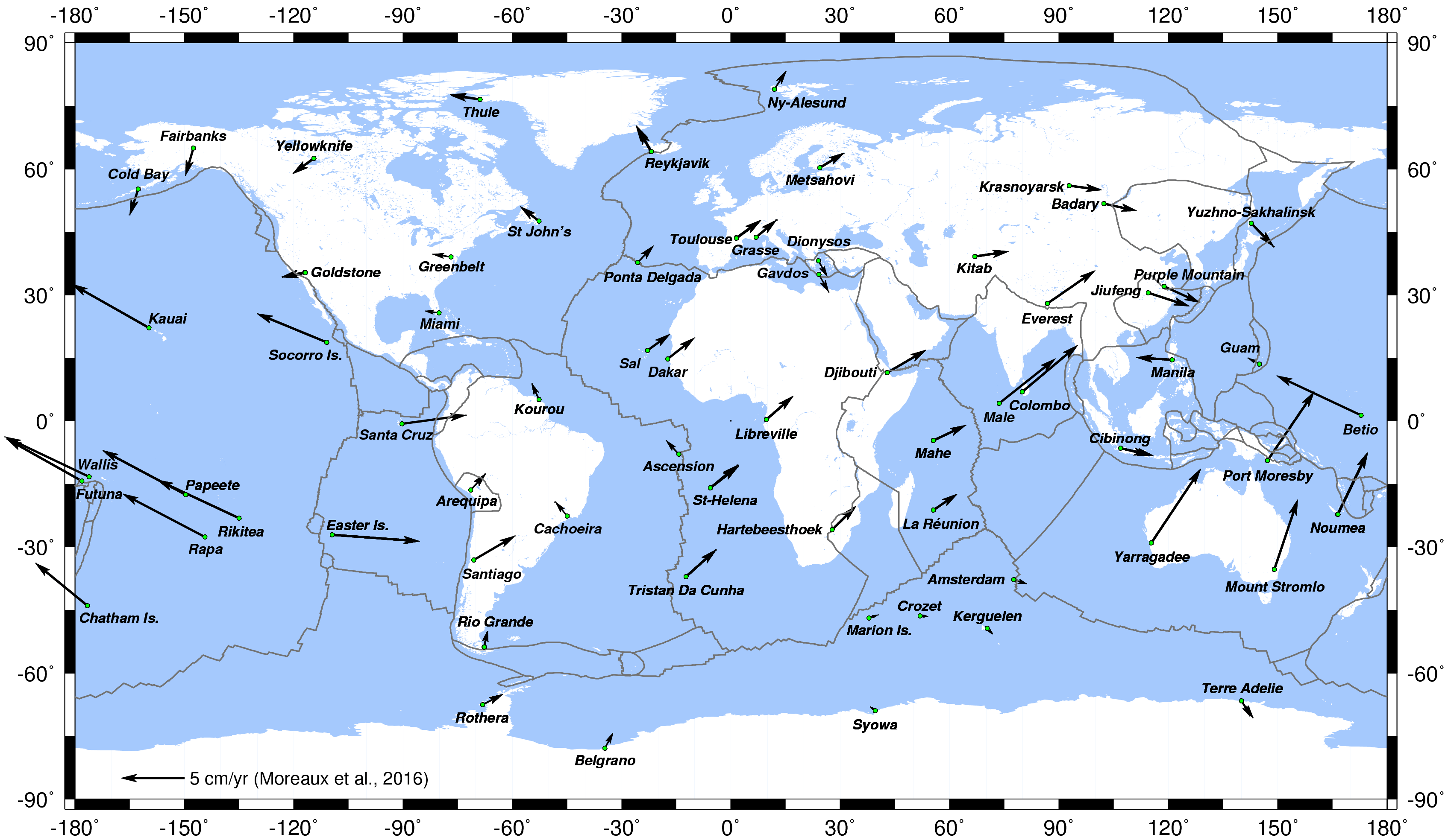
Horizontal displacement of the DORIS stations, reflecting the plate tectonique motion (Credits CNES/CLS/IDS)
Reference: Moreaux et al. (2016)
Currently, six IDS Analysis Centers (ESA, GOP, GRG, GSC, IGN and INA) provide direct input for the official IDS products (station coordinates and Earth Orientation Parameters - EOPs). In addition, after the success of the pilot project to deliver an IDS combined solution for the ITRF2008 realization, the IDS decided to extend the combination process to an operational service. Thus, since 2010, the IDS Combination Center (CC) routinely evaluates the IDS AC station position and EOPs series and combines it to form the official IDS combined solution. The IDS CC is also in charge of the generation of all the DORIS coordinate time series from all the IDS AC (in addition to the IDS CC) SINEX series.
Since the realization of the ITRF2014, the IDS CC is responsible for the elaboration and update of the DPOD solution, i.e. DORIS station positions and velocities for the Precise Orbit Determination (POD) of the DORIS satellites.
All the computations realized by the IDS Combination Center are based on the IGN CATREF (Combination and Analysis of Terrestrial Reference Frames) package (Altamimi et al., 2002).
The Products
Every three months (with a latency of three months), the six IDS ACs submit SINEX solutions including weekly station positions, daily EOPs and the full covariance matrix. After evaluation by the IDS Combination Center, these solutions are combined in a standard least-squares adjustment to form the IDS weekly combined solutions.
The evaluation of the IDS AC solution consists of monitoring the similarity transformation parameters (the Helmert parameters) of the series with respect to the current ITRF realization as well as of analyzing the EOP differences with the IERS C04 series. The Helmert parameters, global station position 3D weighted residuals and EOP differences can be visualized through the IDS web service.
After alignment of the weekly SINEX files on the current ITRF, for all the ACs and all the DORIS stations, the IDS CC generates the coordinate time series. These time series are stored in the STCD files to be downloaded from the IDS Data Centers. Note that these coordinate time series can also be visualized from the IDS web service (see for exemple the time series for Toulouse).
Besides the weekly combined solutions, a long-term DORIS position and velocity cumulative solution is updated and released every three months. In that solution, a piecewise linear (position+velocity) model is used to describe the station motions. The cumulative position and velocity solution is obtained from the stacking of the weekly solution files and is then aligned to the current ITRF. The residuals of this stacking are of particular interest since they depict non-linear station motions.
From the DORIS cumulative solution, the IDS CC generates the DPOD solution. This solution contains positions and velocities of all the DORIS tracking stations for Precise Orbit Determination (POD) applications. It differs from the cumulative solutions by (1) it also includes position and velocity of the newest DORIS stations which were not already observed by the IDS ACs and, (2) between two successive DPOD solutions, for all the stations, we only update the positions if the new ones significantly differ from the previous ones.
To facilitate the access to the geographic positions of all the DORIS stations, the IDS has created the DORIS SINEX Master file.
In addition to the geographic positions of each DORIS station, this IDS product contains information (type and eccentricity) of the antennas in SINEX format. That file, maintained by the IDS Combination Center, is available here or from the IDS Central Bureau ftp site.
dpodYYYY_vx.y.snx.Z: DPOD solution ("YYYY" is the corresponding version of the ITRF (2020, 2014, ...); “x.y” denotes the version number).
dpodYYYY_vx.y.txt.Z: DPOD solution without covariance matrix.
idsyydxx.snx.Z: cumulative solution (“yy” denotes the year of submission and “xx” stands for the series number).
idsyydddwdxx.snx.Z: weekly combined solution (“yy” stands for the last two digits of year of the first observation, “ddd” for three-digit day of year of the first observation, and “xx” for the series number).
idsyywdxx.stcd.aaaa.Z: time series of station coordinates (“yy” denotes the year of submission, “xx” stands for the series number, and “aaaa” denotes the four-character station acronym).
idsyywdxx.stcd.aaaa.gif: plot of time series of station coordinates.
These official products are available at the IDS Data Centers, CDDIS (authenticated access) and IGN (alternate link)

![]()