IDS - International DORIS Service
 
IDS - International DORIS Service
  • IDS
    • Section content
    • Quick reference list
    • Organization
      • About IDS
      • Terms of Reference
      • Structure
      • Governing Board
      • Central Bureau
      • Analysis coordination
      • Analysis Centers
      • Combination Center
      • Data Centers
      • Working Groups
      • Associate Members
    • Meeting calendars
      • IDS Meetings
      • Meetings relevant for IDS
      • Other Calendars
    • Contacts & links
      • Contacts
      • Links
      • Directory
    • Gallery
  • Network & Stations
    • Section content
    • Network browser (sitelogs)
    • Maps
    • Network on Google Earth
    •  Network viewer Network viewer
    •  Station position times series Station position times series
  • Missions & System
    • Section content
    •  The DORIS technique The DORIS technique
    • Missions
    • Satellites in orbit
    •  Orbit residuals time series Orbit residuals time series
  • Data & Products
    • Section content
    • Tables of Data & Products
    • Data structure and formats
    • Information & DC organization
    • Central Bureau https
    •  CDDIS https CDDIS https
    •  IGN ftp://doris.ign.fr/pub/doris/ IGN ftp://doris.ign.fr/pub/doris/
  • User corner
    • Section content
    • Table of system events
    • Day convertor
    •  Network viewer Network viewer
    •  Plot tools Plot tools
      • Station position
      • Position residuals
      • Orbit residuals
      • Combination parameters
      • Earth Orientation Parameters
    • Applications
    • Combination Center
      • Activity & Products
      • Cumulative solution
      • DPOD
      • Contributions to ITRF
    • About DORIS/RINEX format
  • Resources
    • Section content
    • List of the documentation
    • Outreach material
    • Technical documents
    • Articles
      • DORIS bibliography
      • Citation
    • IDS publications
      • Newsletter
      • IDS Activity Reports
    • Presentations
      • Presentations at IDS meetings
      • IDS-related presentations
      • OSTST POD sessions
      • Other publications
    • IDS documents
      • Minutes IDS GB meetings
      • Other IDS documents
      • Mails
    • FAQ

Highlights

Highlights

IDS website is evolving. Find out what's changing

Next AWG meeting: November 6&7, 2025, Athens, Greece

New composition of the IDS Governing Board

A Doppler satellite tracking system

A Doppler satellite tracking system

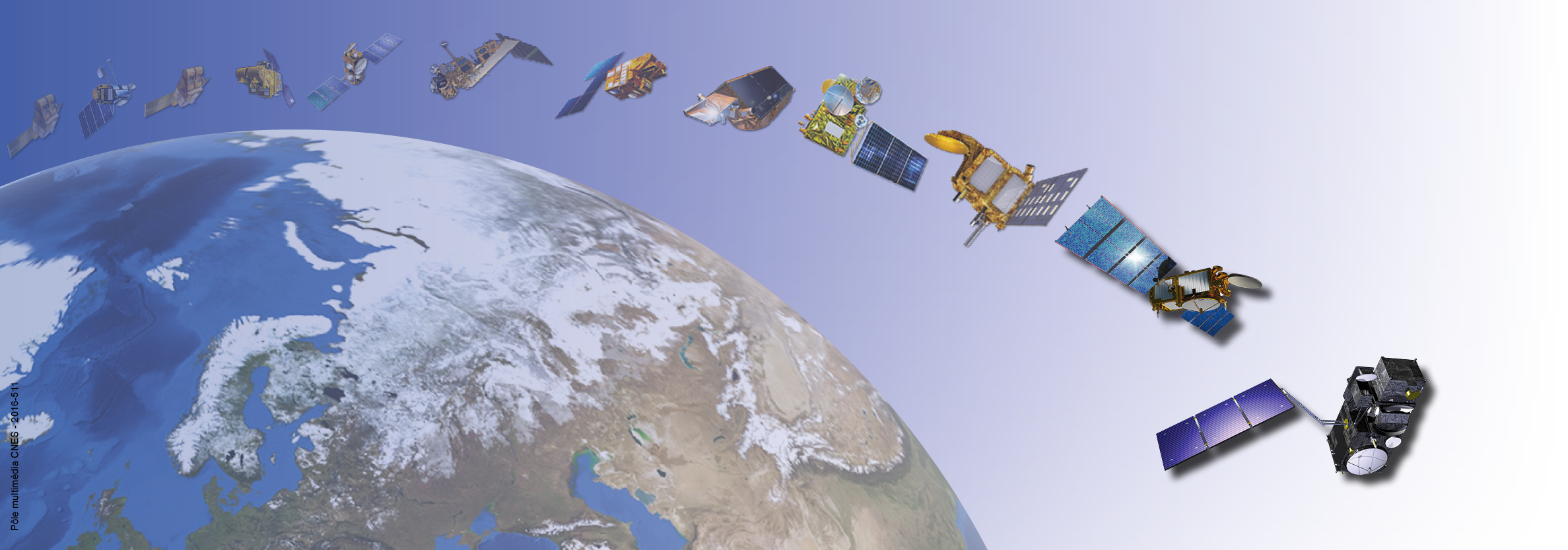
DORIS (Doppler Orbitography and Radiopositioning Integrated by Satellite) is a system developped for precise orbit determination and precise ground location.

The DORIS constellation

The DORIS constellation

DORIS is onboard the Cryosat-2, SARAL, Jason-3, Sentinel-3A, Sentinel-3B, HY-2C, HY-2D, Sentinel-6A and SWOT altimetric satellites. It also flew with SPOT-2, SPOT-3, SPOT-4, SPOT-5, TOPEX/POSEIDON, ENVISAT, Jason-1, Jason-2 and HY-2A.

International DORIS Service

International DORIS Service

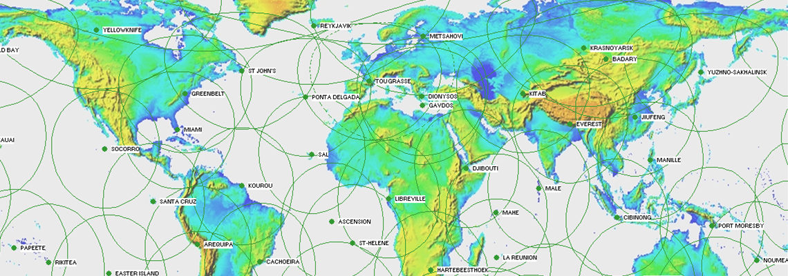
IDS is an international service which provides a support, through DORIS data and products, to geodetic, geophysical, and other research and operational activities.

Previous Next

  1. Home
  2. Network
  3. Network on Google Earth
  4. Network on Google Earth

Discover IDS

  • Organization
  • Table of Data & Products
  • Bibliography
  • Newsletter
  • IDS video channel
  • Presentations at IDS meetings
  • Technical documents
  • Activity reports

Discover DORIS

  • The DORIS technique (AVISO+ website)
  • The satellites
  • The network
  • The stations (sitelogs)
  • Network on Google Earth

DORIS system monitoring

  • Table of system events
  • Visualize products time series
  • POE statistics
  • Network viewer
ICSU-WDS
ICSU-WDS
ICSU-WDS


logo cnes

Site Map |  Contact |  Citation |  Mails |  FAQ |  Glossary
Personal Data Protection Policy |  Legal Notice
Copyright © 1999-2025 CNES-CLS. All Rights Reserved.